California Bike Trails | The Ultimate Guide | Alameda Creek Regional Trail | San Francisco Bay Trail | Paths for Cycling
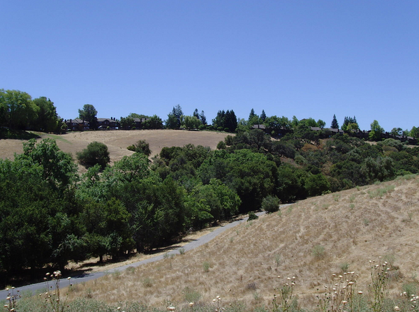
Alameda Creek Regional Trail is a bike trail that follows the Banks of Alameda Creek in California. This gorgeous Trail has wildlife teaming around it, and the rushing creek provides a friendly atmosphere.
The Alameda Creek Regional Trail is a beautiful bike trail that is the most extensive Trail in the county. The Trail itself is massive, as it connects with a series of other trails creating a spiraling and serene journey for cyclists. If you have been to the Alameda Creek Regional Trail or any nearby trails or plan to take a trip, please let us know in the comments below; we hope you have a great experience.
The main bike trail opened up in January 1973 through a project funded by a collaboration of the East Bay Regional Park District, the Alameda County Flood Control and Water Conservation District. In the present day, the Alameda Creek Regional Trail is popular among bikers and hikers alike and provides a great experience.

Alameda Creek Regional Trail
There is a bike trail in southern Alameda County surrounding the Alameda creek. This Trail is named after the stream and is called the Alameda Creek Regional Trails, and it winds down from the mouth of the Niles Canyon and goes toward San Francisco Bay.
The Trail connecting to the south bank of the creek leads to Coyote Mountain Regional Park. From the Alameda Creek Regional Trail, you can make another 3.5-mile loop.
You will enter and exit out of the Coyote Hills and then return to the Alameda Creek Regional Trail for a marathon. For those who want to go longer distances in a shorter time, markers are installed every quarter of a mile along the Trail.
The Trail is easily accessible through Newark, Union City, and Fremont and is non-motorized only.

Alameda Creek Regional Trail History
Alameda Creek is the largest river in Alameda County and is home to many birds and other wildlife. Long ago, its turbulent waters provided valuable resources for the Oloni Indians, who first settled in camps and villages along the coast.
Between 1769 and 1795, members of five Spanish expeditions led by Ortega, Faguis, De Anza, and Amador visited and explored the area. The San Jose Guadalupe Mission Church is located here.
It was put into use in 1797. The 30,000-acre mission lasted 49 years until the settlement mission of the secularization order landed in 1834.
Alameda Creek is the boundary of the mission territory. The 17,000-acre Rancho Arroyo de la Alameda was awarded to Jose de Jesus Valle Huo. Vallejo built a flour-mill near the mouth of the Niles Canyon, and the importance of the gorge as a passage through the hills led to the development of a small town (called Niles today) in the 1850s. Good climate, good soil, and fast-growing population help agriculture to flourish.
The construction of the Transcontinental Railway via Niles Canyon in 1869 and the Central Pacific Transcontinental Railway via the Western Pacific in 1906 improved the transportation of goods-this service is still beneficial to the region.
The Alameda Creek Regional Trail was opened up for public use in January 1973. The project was initially funded by the Water Conservancy Reserve, the Alameda County Flood Control and Water Conservancy Reserve, and the East Bay Regional Park.
The Quarry Lake Regional Recreation Area is located beside the Alameda River and Alameda River Regional Trails. The quarry fish lake has many water-oriented activities, including fishing, boating, swimming, and nature learning.
Alameda Creek Regional Trail Facts
States: California
Counties: Alameda
Length: 22.1 miles
Trail end points: San Francisco Bay and Old Canyon Rd. (Fremont)
Trail surfaces: Asphalt, Crushed Stone
Trail category: Greenway/Non-RT
Activities: Bicycle, Inline Skating, Fishing, Wheelchair Accessible, Horseback Riding, Walking

Alameda Creek Regional Trail and Nearby Trails
The Alameda Creek Regional Trail is a self-sufficient trail on its own. Still, it also connects to various other Trails nearby and creates a beautiful mixture of winding tracks.
The Alameda Creek Regional Trail itself connects with a massive number of other nearby trails that include: San Francisco Bay Trail, Baine Avenue Trail, Quarry Lakes Regional Recreational Area Trails, Embarcadero Bike Path, Stevens Creek Trail, Permanente Creek Trail, Bol Park Path, Sabercat Creek Trail, Matadero Creek Trail, Crystal Springs Regional Trail, Guadalupe River Trail, and Highway 237 Bikeway.
All these trails and bike paths are connected to one another in one way or the other, and you can travel the long winding roads for an infinite amount of time if you wanted.
1. San Francisco Bay Trail
The San Francisco Bay Trail took on massive effort to create a 500-mile multipurpose trail around the bay of the same name. The Trail will connect 47 cities in 9 counties along this route, providing many connections for buses, local employment centers, parks, open spaces, schools, and other civic centers.
As of 2017, more than 300 miles of trails have been opened, cross-country trails with multiple surface types, and stretches of bicycle and sidewalk.
The Trail creates an incredibly diverse network through the peaceful extension of the Don Edwards San Francisco Bay National Wildlife Refuge and China Camp State Park, which seems to be connected to the bustling Port of Oakland or the active Union Pacific Railroad Cargo Company and Amtrak's Capitol Corridor.
San Francisco Bay Trail Facts
States: California
Counties: Alameda, Contra Costa, Marin, Napa, San Francisco, San Mateo, Santa Clara, Solano, Sonoma
Length: 301.5 miles
Trail end points: California State Route 237 (San Jose) and Kennedy Park (Napa)
Trail surfaces: Asphalt, Boardwalk, Concrete, Crushed Stone, Dirt, Gravel
Trail category: Rail-Trail
Activities: Bicycle, Inline Skating, Fishing, Wheelchair Accessible, Walking

2. Baine Avenue Trail
Baine Avenue Trail is a short-gauge railway track that follows the active United Union Pacific Railroad corridor in Newark's heart. Unpaved trails are more commonly used as neighborhood connectors or shorter leisure routes.
The Civic Center Park at the southern end of this Trail is a highlight, which includes rides, picnic facilities, basketball courts, and the local Alameda County Library branch.
Baine Avenue Trail Facts
States: California
Counties: Alameda
Length: 0.75 miles
Trail end points: Civic Center Park on Baine Ave. and Cedar Blvd. and St. Isabel Ave.
Trail surfaces: Dirt, Gravel
Trail category: Rail-Trail
Activities: Bicycle, Walking
3. Quarry Lakes Regional Recreation Area Trails
The Quarry Lake Regional Recreation Trail area provides a variety of activities. In addition to car-free roads for biking, walking, and horse riding, the park also offers boating, swimming, fishing, picnics, and beach sports. Leashed dogs are allowed.
The recreation area and its loop trail are conveniently located on the Alameda Creek area trail, which leads to the more extensive network of San Francisco Bay trails at the west end.
Quarry Lakes Regional Recreation Area Trails Facts
States: California
Counties: Alameda
Length: 5.38 miles
Trail end points: Isherwood Way/Quarry Lakes Dr. and Alameda Creek Regional Trail
Trail surfaces: Crushed Stone
Trail category: Greenway/Non-RT
Activities: Bicycle, Horseback Riding, Walking
4. Embarcadero Bike Path
The Embarcadero bike path is an essential connection point between the local commuter rail, schools, and the business district on the west side of Palo Alto and the suburbs of Stanford University.
The paved road is very close to the Caltrain tracks from Palo Alto Station to Palo Alto High School campus, and its configuration is commonly known as "rail-to-rail." The Trail is surrounded by Trees, ample lighting, proper landscaping, and protective fences to make the experience enjoyable and safe.
If you go near the northern end of the Trail, you can see the El Camino Park, the oldest park in the city built back in 1914.
Embarcadero Bike Path Facts
States: CaliforniaCounties: Santa Clara
Length: 0.9 miles
Trail end points: Palo Alto Station and Churchill Ave. and Castilleja Ave.
Trail surfaces: Asphalt
Trail category: Rail-Trail
Activities: Bicycle, Inline Skating, Wheelchair Accessible, Walking
5. Stevens Creek Trail
The Stevens Creek Trail is an open path in two unconnected parts of the two communities in Silicon Valley, Mountain View, and Cupertino. As the name says, both tracks immediately follow Stevens Creek, which originated in the Santa Cruz Mountains and goes out into San Francisco Bay.
The northern section of Mountain View starts overlooking the junction with the San Francisco Bay Trail. This is a development project aimed at creating a 500-mile multipurpose trail around the bay of the same name.
Heading south from the 750-acre Coastline Park, this Trail passes through tidal marshes and natural riparian habitats, providing ample educational and recreational opportunities for the people visiting.
Stevens Creek Trail Facts
States: CaliforniaCounties: Santa Clara
Length: 5.9 miles
Trail end points: San Francisco Bay Trail in Shoreline Park and Dale Ave. and Heatherstone Way (Mountain View); Stevens Creek Blvd. to McClellan Rd. (Cupertino)
Trail surfaces: Asphalt
Trail category: Greenway/Non-RT
Activities: Bicycle, Inline Skating, Wheelchair Accessible, Walking
6. Permanente Creek Trail
The Permanente Creek Trail provides a straight route through Mountain View city's outskirts, starting from the Mountain View Coastline and going south to Rock Street. The paved road includes the safe passage of Highway 101 with bicycle and pedestrian bridges.
The park's northern end covers 750 acres, bordering San Francisco Bay, and has golf courses, lakes, and trails with mountain views and abundant wildlife. On the south side of the park, this Trail is adjacent to the campus where Google's headquarters are located and extends to Crittenden Middle School.
Since 2016, plans are being made to expand the Trail south to Middlefield Road through the school campus.
Permanente Creek Trail Facts
States: California
Counties: Santa Clara
Length: 1.5 miles
Trail end points: Shoreline At Mountain View and Rock Street
Trail surfaces: Asphalt, Concrete
Trail category: Greenway/Non-RT
Activities: Bicycle, Inline Skating, Wheelchair Accessible, Walking

7. Bol Park Path
Bol Park Path is an attractive place, passing through a quiet neighborhood of Palo Alto in the mountains south of San Francisco. Its core is Bol Park, with a playground and lawn next to Matadero Creek.
The area was once home to a donkey ranch, and the remaining two donkeys greet visitors from a private corral along a path. This Trail is also very popular with students who use the Trail to reach Gunn High School at the southern end of the Trail on weekdays.
Bol Park Path Facts
States: California
Counties: Santa Clara
Length: 1.25 miles
Trail end points: Hanover St. and Miranda Ave. and Arastradero Rd.
Trail surfaces: Asphalt
Trail category: Rail-Trail
Activities: Bicycle, Inline Skating, Wheelchair Accessible, Walking

8. Sabercat Creek Trail
The Sabercat Creek Trail, along its tree-lined waterway of the same name, can be found in Fremont's Mission San Jose community (a California coastal city outside San Francisco Bay).
This 2-mile-long paved road passes through a former paleontological excavation site, where thousands of fossil specimens have been collected, including mammoths, saber-toothed cats, wolves, giant sloths, and cave bears.
Mission San Jose Park has restrooms, picnic tables, playgrounds, and sports facilities near its eastern end.
Sabercat Creek Trail Facts
States: California
Counties: Alameda
Length: 2 miles
Trail end points: Pine St. and east of I-680
Trail surfaces: Asphalt
Trail category: Greenway/Non-RT
Activities: Bicycle, Wheelchair Accessible, Walking
9. Matadero Creek Trail
The Matadero Creek Trail, also commonly known as the Page Mill-Arastradero Connector, winds through gently rolling hills and countryside, offering beautiful San Francisco Bay and the Santa Cruz Mountain views.
The Trail from Junipero Serra Boulevard (Junipero Serra Boulevard) to Deer Creek Road is paved on the north side, abutting Page Mill Road, and is open to cyclists and walkers.
Cyclists should be aware that the southern half of the Trail from Deer Creek Road to Arastradero Road is overcrowded and is only available to pedestrians.
Matadero Creek Trail Facts
States: California
Counties: Santa Clara
Length: 1.5 miles
Trail end points: Page Mill Rd. and Foothill Expy. /Junipero Serra Blvd. (Palo Alto) and Arastradero Rd. across from Purissima Road (Los Altos Hills)
Trail surfaces: Asphalt, Dirt
Trail category: Greenway/Non-RT
Activities: Bicycle, Walking

10. Crystal Springs Regional Trail
The Crystal Springs Regional Trail is a developing network of trails consisting of three different parts: San Andreas, Sawyer Camp, and Crystal Springs. The two sections of wide, flat paved trails in the north surround the east bank of Lake San Andreas and the Lower Crystal Springs Reservoir, while the southern area is a narrow dirt road that runs along Cañada Road and the Upper Crystal Springs Reservoir.
Also, it is limited to hikers, joggers, and equestrian enthusiasts only. The San Andreas network segment extends from San Bruno Avenue in the north to Hillcrest Boulevard near San Andreas Lake's southern end, where it is seamlessly connected to the Sawyer Camp network segment.
Crystal Springs Regional Trail Facts
States: California
Counties: San Mateo
Length: 16.5 miles
Trail end points: Skyline Blvd. /SR 35 and San Bruno Ave. (San Bruno) and Raymundo Dr. at Huddart Park (Woodside)
Trail surfaces: Asphalt, Dirt
Trail category: Greenway/Non-RT
Activities: Bicycle, Fishing, Wheelchair Accessible, Horseback Riding, Walking

11. Guadalupe River Trail
The Guadalupe River Trail is the backbone of San Jose's growing trails network, running north and south across the city. Part of the Trail runs along the Guadalupe River banks, and signs tell the trail users where they must cross.
The plan calls for linking the two open sections of the Trail in the future; currently, tracking users must experience these two sections separately. The northern part begins with Alviso, a community at the southern end of San Francisco Bay.
The Trail here connects to the Highway 237 bike lane, part of the larger San Francisco Bay Trail. The latter is an ambitious work to create a 500-mile multipurpose trail around its namesake bay.
Guadalupe River Trail Facts
States: California
Counties: Santa Clara
Length: 12.5 miles
Trail end points: San Francisco Bay Trail at Gold St. (Alviso) and Los Alamitos Creek Trail at Almaden Lake Park on Coleman Rd. (San Jose)
Trail surfaces: Asphalt
Trail category: Greenway/Non-RT
Activities: Bicycle, Inline Skating, Wheelchair Accessible, Walking

12. Highway 237 Bikeway
The bike lane of Highway 237 runs parallel to Interstate 237 between McCarthy Boulevard in Milpitas and Calabazas Creek in Sunnyvale.
This Trail has two main parts: the first is between McCarthy Avenue and Zanker Road (on both sides of the highway), and the second is between N. First Street and Calabazas Creek, from the south to the north of the highway.
On Lafayette Street. Between N. First Street and Zanker Road, you can drive along the dedicated bike lane on Holger Way.
Highway 237 Bikeway Facts
States: California
Counties: Santa Clara
Length: 5 miles
Trail end points: McCarthy Blvd. (Milpitas) and Calabazas Creek (Sunnyvale)
Trail surfaces: Asphalt
Trail category: Greenway/Non-RT
Activities: Bicycle, Inline Skating, Wheelchair Accessible, Walking

Click Here To Get => California Cycling Jersey
If you have cycled any of these trails and/or plan to take a trip on any of these trails, please let us know in the comments below. Ride safe and have fun!